GIS Tools
The set of Geographic Information Systems (GIS) Script Tools for Renewable Energy (RE) zoning enable stakeholders to customize the zoning analysis by changing parameters and input files to meet the specific needs of each stakeholder or to best represent the country context.
Update spatial outputs
Script Tool A enables the user to perform step 4b (Calculation of zone attributes; see Figure 1 below) with updated inputs and parameters for a country using the spatial outputs available under Spatial Data sections of projects. The script has been tested on countries in the Southern and Eastern Power Pool study region. The outputs of this tool can be used to update the zone ranking tool.
Estimate resource potential and create project opportunity areas for any region of the world
Script Tool B, Stage 1 allows the user to create a site suitability map, which is effectively a spatially-explicit way to estimate resource potential, using any exclusion and renewable resource inputs provided by the user (stage 1 in Figure 1). These site suitability maps can be used to create project opportunity areas (stage 2 in Figure 1) and estimate their attributes using user-specified inputs (stage 3 in Figure 1) with Script Tool B, Stages 2 and 3. Users must have their own spatial datasets in order to use Script Tool B. Step 4a (Creation of Zones) has not been included in these Script Tools or zoning manual due to the the need for additional third-party software.
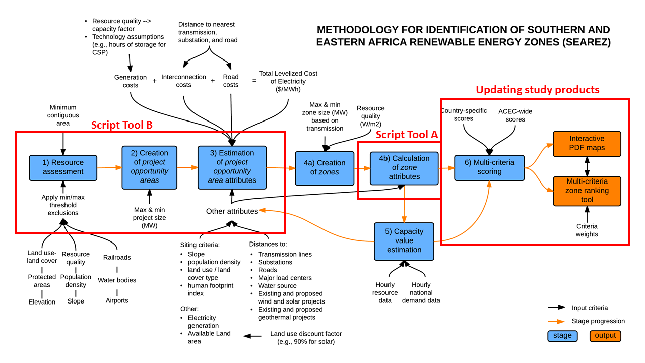
Figure 1. Flowchart showing the renewable energy zoning methodology used in the original zoning study. The red boxes indicate steps in the methodology that can be re-created or updated using the RE zoning GIS tools.
Downloads
Download version 1.4 (released 08/25/2017) of the GIS Script Tools for RE zoning:
You must have ArcMap 10.2+ in order to use these script tools.
Through examples and tutorials, the accompanying User Manual describes the key geoprocesses involved in performing the zoning analysis using the RE zoning study’s assumptions. Finally, the user can update two products of the zoning studies (if available), the interactive PDF map and the Excel zone ranking tool.
View User Manual (google doc) ArcMap 10.2+ (last updated 2/24/2017)
Download datasets for tutorials in the User Manual (119 mb)
To access MapRE scripts updated for ArcGIS Pro, please visit the Clean Energy Transformation Lab (CETlab) github page for MapRE.
View User Manual (google doc) ArcGIS Pro (last updated 08/2021)
Version history:
2016-08-13 (v1.1):
– Updated metadata for tutorial 1’s included datasets. Replaced example Kenyan power plant csv and point file datasets with example Kenyan load datasets. Updated user manual accordingly.
– Minor modifications to Option 1 scripts for all technologies to report distances calculations with more precision, reducing rounding differences compared to original zones and project files.
2016-11-01 (v1.2):
– Updated Script Tool B-2 to create project areas for any region of the world, as specified by the template raster. Previously, projects could only be created for regions within the African continent.
2017-01-26 (v1.3):
– Updated Script Tool B-2 to fix a bug having to do with the template raster. The tool should now run with any template raster provided.
2017-08-25 (v1.4):
– Updated Script Tool B-3 to change the application of the transmission distance multiplier parameter. In previous versions, this user input was linearly applied to the calculated euclidean distance and reflected in the distance calculation column. Now, the multiplier is only applied for the calculation of the transmission or substation LCOE and total LCOE. The distance columns should show unmodified euclidean distances.
Please contact gracecwu [at] ucsb.edu or rdeshmukh [at] ucsb.edu to report issues and bugs.